Study Area Profile: Changthang, Ladakh
Study Area is of prime importance in Geography as a spatial discipline. A study area profile is a key tool that aids in understanding the conceptual background of the area under investigation for in-depth research. This chapter serves as an introduction to Changthang, highlighting its administrative background, the physical environment, and the socio-economic characteristics of the region. These aspects are crucial precursors to the research, providing a fundamental understanding of the region’s significance.
Keywords
Physiography· Demography· Social-economic Changes
1. Introduction
The study area of Changthang, also called the Northern Plains, lies in Eastern Ladakh and represents the South Western-most extension of the Tibetan Plateau. The region extends into India in the Union Territory of Ladakh. The northern plains of Changthang constitute a vast desert-steppe area covering approximately 40% of Ladakh’s landmass and is a distinct biogeographical zone. @Humbert-Droz, 2023, @WWF-India 2007 framework report. The region is dotted with lakes and traversed by the headwaters of two major South Asian rivers, the Indus, and Sutlej (Parang Chu River). The region has three major lake basins: Tsomoriri, Tsokar and Pangong Tso. Changthang lies in district Leh of the recently recognised Union Territory of Ladakh. District Leh has nine community development blocks out of which Nyoma and Durbok are part of Changthang. These two blocks comprises a total of 23 villages as per the 2011 census. @DCH2011PartA
2. Research Rationale
2.1 Rationale for the Selection of the Research Topic
Divide it into two parts (Justification for studying ecological landscape mapping, Importance of habitat changes analysis, Relevance of socio-economic transformation study and Research gaps and contribution)
2.2 Rationale for the Selection of Study Area
3. Historical Background
 In the first paragraph explain Changthang's Origins, using the gazetteers and the book antiquities of Indian Tibet , What does the present govt call your region?

  In second paragraph, write the historical background, the oldest inscriptions to the medieval kings and the modern rulers and the colonial time,  and the control of the state under the present government
4. Administrative Background
Question: should I write this section according to the current subdivisions of the union territory or stick to 2011 census data? There is a lot of change in the new administrative divisions. Earlier version of the study area profile had the data from the 2011 census.
Where should I explain the whole of Ladakh as a physio-cultural region ?
4.1 Administrative Boundary
==Explain the location of the main district, explain the boundaries international, state, district and the natural barriers like rivers and mountain ranges, neighbouring areas on all sides be named, geographical area extent, lat long
According to the administrative atlas of Jammu and Kashmir published by the Census of India in 2011, Ladakh was among its twenty-two districts. However, significant changes have occurred since then. Following the abrogation of Article 370 on August 9, 2019, the Parliament of India passed the Jammu and Kashmir Reorganization Act 2019. This Act led to the State’s bifurcation into two Union Territories, Jammu and Kashmir and Ladakh, the latter being the focus of our study.
Since 2019, Ladakh has been a Union Territory of India. It is composed of two districts, Leh and Kargil. District Leh, the primary focus of our study, is divided into three sub-districts or tahsils: Leh (Ladakh), Nubra, and Khalsi; all three are the tahsil headquarters. China and Tibet surround sub-district Leh(Ladakh) on the north and the east. The State of Himachal Pradesh borders it on the south, the district of Kargil, and the two other tahsils of Nubra and Khalsi on the east.
Over the years, the region’s administrative setup has changed during the census intervals. In 1961, the administrative divisions of district Leh comprised two tahsils, namely Kargil and Leh. The administrative map of the region from 1971 depicts new changes in the composition of district Leh(Ladakh). It remains a part of the erstwhile State of Jammu and Kashmir, and the district Leh(Ladakh)is divided into three tahsils: Leh(Ladakh), Kargil and Padum(Zanskar). Sub-district Leh was carved out in July 1979 to make it administratively and operationally easier to accelerate the process of eradicating the socio-economic backwardness of the region. District Leh(Ladakh) remained the same in 1981, and the sub-districts of Kargil and Padum(Zanskar) were now part of district Kargil as tahsils. In 2001, the divisions remained the same as in 1981. Some changes in the administration happened with new Tahsils in 2011, namely Leh, Nubra and Khalsi under district Leh and Kargil and Sanku and Zanskar under district Kargil.
Insert Table: Columns: Map Year District and Headquarter Subdistrict/Tahsil and Headquarter Values:
==Also add a map of the administrative boundary of Ladakh as a UT and explain the new setup
4.2 Administrative Setup
Sub-district Leh(Ladakh) has national highway NH1A across the district. The district has one Statutory town called Leh(M.C.) and two Census Towns, Spituk and Chuglamsar. @Footnote_1(Explain the difference between the two) The Indus River system flows through the vast geographical territory of Ladakh.
Footnote: The data in the census are presented separately for rural and urban areas. The unit of classification in this regard is ‘town’ for urban areas and ‘village’ for rural areas. The urban area comprises two types of towns viz; Statutory towns and Census towns. In the Census of India 2011, the definition of urban area adopted is as follows: (a) Statutory Towns: All places with a municipality, corporation, cantonment board or notified town area committee, etc are known as statutory towns. (b) Census Towns: All other places satisfying the following three criteria simultaneously are treated as Census Towns. i) A minimum population of 5,000; ii) At least 75 per cent of male working population engaged in non-agricultural pursuits; and iii) A density of population of at least 400 per sq. km. (1,000 per sq. mile)
This paragraph will include the govt of India sanctioned administrtaive setup, when was the district made, district names, subdivisions, police sations, community developemnt block, municipality wards, census towns and inhabited villages, due to recent changes you have to add the former administratvie set up in detail, since the 2011 census is your base for the secondary data and then add the present context, if the changes are avaialble in government documents mention them.
4.3 Location of Study Area
The following paragraph includes description of the physical location of the subdivisions and or cd blokcs in focus, if they are surrounded by a river or a mountain range, the coordinates of the cd blocks or the tehsil headqurters, information about the lat longs passing through the region
Give simple infromation about the census satistics such as no of households in the chosen cd blocks, no of muinicipalities, tehsils, census towns, wards, and villages, the total geographical area of the study area in comparison to the district, total population as per the most recent census data
5. Physical Background:
Add a Map of the study area showing the basic categories of Land use and Land Cover "Titled: Land Use And Land Cover Map Of The Study Area"
5.1 Geology:
==Not my writing
The Ladakh region, located in the northwestern Himalaya, forms a key segment of the complex tectonic framework that characterizes the India–Eurasia continental collision zone. The Ladakh Batholith and its associated geological features within the vicinity of Leh, lies within the broader Kohistan–Ladakh Arc Terrane (KLA). The KLA represents a significant crustal fragment that originated as an island arc within the Tethys Ocean during the Jurassic to Cretaceous periods. Its evolution through time, shaped by successive tectonic collisions, has left a distinct geological imprint that is crucial for understanding Himalayan orogenesis.
The Ladakh Batholith is a prominent geological unit within the KLA, constituting part of the 2700 km-long Trans-Himalayan magmatic arc that stretches from Afghanistan through northern Pakistan and Ladakh into Tibet and Myanmar. The batholith extends approximately 700 km in a NW–SE direction and is composed of Jurassic–Miocene volcanic, sedimentary, and predominantly plutonic rocks. These rocks include gabbros, diorites, granodiorites, and granites, which were emplaced in multiple magmatic episodes and subsequently deformed during the Himalayan tectonic events.
Tectonically, the batholith’s evolution reflects three principal phases: initial formation as an intra-oceanic island arc (Jurassic to ~90 Ma), transition to an Andean-style active continental margin (~90–50 Ma), and eventual integration into a continent–continent collision zone (~50 Ma onwards). This tectonic progression is supported by a range of models that, while differing in the timing and nature of collisions and subduction polarity, agree broadly on the sequence of events. The KLA first collided with the Eurasian Plate (~90–85 Ma), followed by overthrusting by the Indian Plate (~55–50 Ma), resulting in its present position between two converging continental blocks.
The regional tectonic boundaries—namely, the Northern-Shyok Suture Zone to the north and the Indus Suture Zone to the south—delineate the KLA from adjoining terranes of the Eurasian and Indian plates, respectively. These sutures are zones of intense deformation and provide important structural context for interpreting crustal processes in the region.
Topographically, the Ladakh region exhibits a rugged and high-altitude terrain shaped by ongoing tectonic activity. Elevations range from around 3200 m in the Indus River floodplain to over 5500 m in the northern ridges. The geomorphology features glacially carved amphitheatre valleys, thrust-generated ridges, and expansive alluvial plains. Notably, valleys north of the Indus River are broader and more developed due to glacial and fluvial incision, whereas southern valleys are narrower and structurally confined. The region experiences a cold desert climate, with minimal annual precipitation (~10–12 cm), sparse vegetation, and extreme diurnal temperature variations. These arid conditions enhance bedrock exposure, providing exceptional opportunities for detailed structural and lithological changes.
This includes information on the morpho and litho stratigraphy of the region, find a reliable source, I have limited information about this, it will take some time
describe and explain what you know about ladakh first, changthang specific information might not be readily available
describe and explain the landforms present in the region in detail, types of the concerned landforms, rock formation and types and its details, explain endogenic and exogenic landform processes in detail,
 Describe the tectonic processes, faults and folds
 add A map of the gelogical landscape of the study area from a relaible source or make one yourself in QGIS
5.2 Relief:
Explain the physiography of the region, the mountain systesm and its zones, its glacial topography, the erosion and depositional features of the glacier landforms, river that flow throgh the region and the places that they flow next, any regional disaster related issues like floods and landslides, the elevation of the region to be explained as well, including the average height of the region
there will also be a surface relief map of the region added to this section, titled "Surface Relief Map of Changthang", source " "
5.3 Drainage:
This will include an explanation about the river system of the region, what type, where they originate, whether they are snow fed, where they enter and exit the study area and what happens to the rivers in its ongoing stages
Explain all the river systems in detail
There needs to be a table titled " Major River Systems of the district"
There is also going to be a map of the system titled " Drainage System of Changthang"
 This is how the table looks like:
| S.NO | Name of River | Source | Local Name | Length | Basin Area | Mouth | Tributaries | Basic Features |
|---|---|---|---|---|---|---|---|---|
5.4 Climate:
Explain what you already know about the region's Climate @IMD Tables for Leh
4.4.1 Temperature:
4.4.2 Rainfall:
5.5 Ground Water and Irrigation:
==Not my writing
As per the Ground water resource assessment carried out by the Central Ground water Board in 2024, the groundwater resources of the Ladakh(UT) have been assessed on block level in 2 districts.
The topography of the region is extremely rugged, mountainous, and highly inaccessible. Leh plain is underlain by morainic deposits consisting of boulders, cobbles, pebbles embedded in an arenaceous matrix and the lake deposits comprising predominantly of clays, sandy-Clays and silt. The sediments are overlain by varved clays and silts of lacustrine origin again succeeded by morainic boulders and cobbles in disintegrated loose sandy matrix and alluvial deposits. Groundwater in the valleys occurs in porous formations. This includes moraines and fluvio-glacial deposits of Ladakh. Kargil District comprises of the Suru, Zanskar, DrassShamkerChikar, Waknaand Laws valley’s. Groundwater occurs mainly in the porous formations of morainic deposits consisting of Talus and Scree formations.
The total recharge of ground water involves several components like rainfall/ snowfall being the major one. The other components are seepage from canal, kuhls and return flow from surface water and ground water irrigation. The UT has a total of 963 Sq. km recharge worthy area. The average area reported for the Assessment Unit is 53.50 Sq. km.
As per the report Total Annual Ground Water Recharge of the UT has been estimated as 0.07 bcm (Billion Cubic Meters) and Annual Extractable Ground Water Resources is 0.06 bcm. The Total Current Annual Ground Water Extraction is 0.02 bcm. The Stage of Ground Water extraction in Ladakh is 30.93 %. Out of the total 18 Assessment Units, 1 AUs (5.56%) of Leh are categorized as ‘Semi Critical’ and remaining 17 AUs (94.44%) are categorized as ‘Safe’. The number of semi-critical assessment units has reduced from six to one since 2023. There has also been a reduction in the stage of the percentage of ground water extraction in Ladakh from 37.05% in 2023 to 30.93% at present.
5.6 Natural Vegetation:
==Not my writing
Ladakh: Reserved Forest Area: 7 km2 out of 2,22,236 notified geographical area km2 which is the total area for Jammu and Kashmir plus Ladakh (shapefile area : 1,68,055 km2)
Ladakh encompasses a geographical area of 1,68,327 km². As per the 2011 Census, the population—including Jammu and Kashmir—is approximately 12.54 million, predominantly rural (72.62%). Livestock density is also significant, with 9.20 million animals recorded in the 19th Livestock Census. Administratively, Ladakh is composed of two districts—Leh and Kargil—both designated as hill districts.
Forest Cover and Land Use
The total forest cover in Ladakh is reported as 2,285.92 km², constituting 1.36% of its geographical area. The forest types are categorized into Very Dense Forest (VDF) – 2.27 km², Moderately Dense Forest (MDF) – 509.07 km², and Open Forest (OF) – 1,774.58 km². Additionally, scrublands occupy 325.49 km². Leh dominates with 2,227.66 km² of forest, whereas Kargil contributes only 58.26 km². These figures highlight the sparse vegetation typical of cold desert regions.
Inside vs Outside Recorded Forest Area
A notable feature is that only 794.58 km² of forest lies within Recorded Forest Areas (RFA), while 1,491.34 km² exists outside. This spatial discrepancy underscores the need for reconsidering traditional forest boundary demarcations in remote landscapes like Ladakh.
Altitudinal and Slope-based Distribution
Forest distribution varies markedly with elevation. The majority (1,161.22 km²) is found between 3,000–4,000 meters, while areas above 4,000 meters account for only 21.07 km² due to climatic constraints. In terms of slope, forest cover increases with steeper gradients: 794.58 km² is located on slopes greater than 30°, suggesting rugged terrain supports the majority of forested areas.
Forest Types
Using Champion and Seth’s classification, the report identifies 14 forest types:
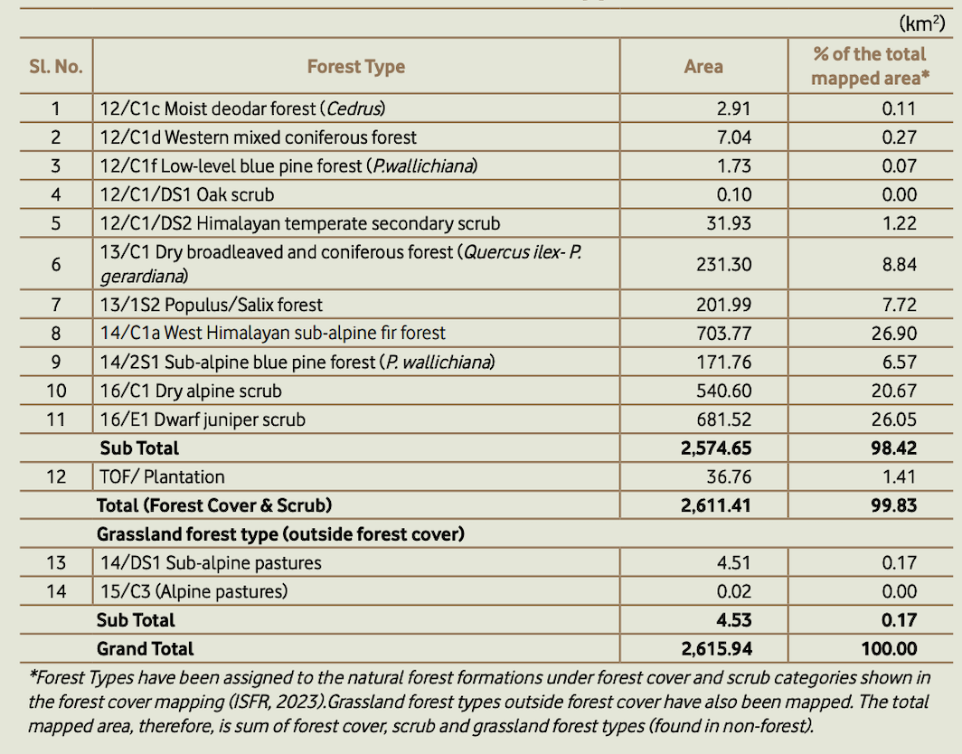
Fire Proneness and Incidence
Forest fire risk in Ladakh is minimal. According to Table 10.34.10, only 20 and 32 fire incidents were recorded in Leh during the 2022–23 and 2023–24 fire seasons, respectively, while Kargil reported only one fire. The fire proneness classification reveals that 99.19% of the forest is “less fire prone,” and no area is classified as “highly” or “extremely” prone.
Tree Resources
Tree species composition reflects the region’s ecological character. In rural areas, Salix spp. and Populus spp. dominate, accounting for 38,818 and 28,668 trees respectively, contributing a combined volume of nearly 20 million m³. Urban areas show significantly reduced tree presence.
In conclusion, the forested landscape of Ladakh, though limited in extent, exhibits considerable ecological diversity. Its predominance outside traditional RFA boundaries and in steep, high-altitude terrains necessitates a localized and adaptive management framework.
5.7 Soil and Land Use Types:
==Not my writing
Soil found in the high mountainous areas is different in nature depending upon altitude, vegetation cover, slope etc. Texture of soil becomes coarser as the altitude increases. Amount of soil moisture differs with degree of slope gradient. On the steep slope, water will flow quickly while low gradient ensure slow discharge and as a result, there will be more soakage. Low gradient restricts agriculture, mainly confined it to valleys, which have more calcareous soil that are alkaline in nature. Soil generally is skeletal in nature and thickness of soil cover increases only in river valleys. However, most of Ladakh has sandy soil. Table below shows that Drass valley having the highest proportion of silt. As against this, fine sand dominates in Kargil, Suru and Zanskar. In general, the soils of Ladakh are poor in moisture content due to intense insolation and aridity and have less water retention capacity. Farmers use animal dung and human night soil as fertilizer in order to enhance productivity. However, chemical fertilizers have started being used on large scale along with local manure in recent decades.
Mechanical Analysis of Soil in Ladakh (%)
| Place | Coarse (%) | Fine Sand (%) | Silt (%) | Clay (%) | Texture |
|---|---|---|---|---|---|
| Drass | 0.88 | 19.82 | 53.90 | 25.00 | Silt Clay |
| Kargil | 6.44 | 61.10 | 3.30 | 20.50 | Loamy clay |
| Leh | 4.17 | 24.83 | 2.50 | 8.50 | Loamy sand |
| Suru | 1.00 | 58.55 | 28.50 | 12.00 | Loamy |
| Zanskar | 3.77 | 54.82 | 15.00 | 25.50 | Sandy clay |
| Source: Department of Agriculture, J&K State. |
6.Socio-economic Background
6.1 Demographic Characteristics:
6.2 Literacy Status and Sex Composition:
6.3 Religion and Caste Composition:
6.4 Occupational Structure:
6.5 Infrastructural Facilities:
Note: also add health and education institutes, and law enforcement facilities
7. Discussion:
Found literature on Out-Migration
8. References:
References:
-
Ahmed, M. (2004). The politics of pashmina: the Changpas of eastern Ladakh. Nomadic Peoples, 8(2), 89–106. https://doi.org/10.3167/082279404780446041 { This is from Nomadic Peoples. It is available on Scopus Elsevier. https://www.liverpooluniversitypress.co.uk/journal/whpnp }
-
Jamieson, S., Sinclair, H., Kirstein, L., & Purves, R. (2004). Tectonic forcing of longitudinal valleys in the Himalaya: Morphological analysis of the Ladakh Batholith, North India. Geomorphology, 58(1–4), 49–65. https://doi.org/10.1016/S0169-555X(03)00185-5 { This is from Geomorphology, available at Elsevier. https://www.sciencedirect.com/journal/geomorphology/about/insights }
-
Jamwal, P., Shrotriya, S., & Takpa, J. (2020). The pattern of waterbird diversity of the trans-Himalayan wetlands in Changthang Wildlife Sanctuary, Ladakh, India. Journal of Threatened Taxa, 12(1), 15129–15139. https://doi.org/10.11609/jott.5122.12.1.15129-15139 {should be helpful, indexed in Scopus as per its page info https://threatenedtaxa.org/index.php/JoTT/aims_scope }
-
Pandit, A., Mir, M., Mir, M., Wani, Y., Bisati, I., Un Nisa, S., Khan, H. M., & Shah, R. A. (2024). Pastoralism in Changthang, Ladakh: Adaptations, challenges, and pathways for sustainability. Mountain Research and Development, 44, A1– A7. https://doi.org/10.1659/mrd.2023.00028 {https://bioone.org/journals/mountain-research-and-development/volume-44/issue-1/0276-4741-44.1.p2/Publisher-Information/10.1659/0276-4741-44.1.p2.full this is the indexing information, has the web of science in indexing, I think it qualifies as a good journal}
-
Sharma, I., & Sidhu, A. K. (2011). Review and present observations on the sighting of Black-Necked Crane, Grus nigricollis Przheylsky from Ladakh (Jammu and Kashmir, India). Nomadic Peoples. { Just as the first one, it qualifies }
-
Uniyal, S., Awasthi, A., & Rawat, G. (2005). Biomass availability and forage quality of Eurotia ceratoides Mey in the rangelands of Changthang, eastern Ladakh. Current Science, 89(2), 201–205. {https://www.currentscience.ac.in/about.php This has proper indexing and probably qualifies}
-
Namgail, T., Van Wieren, S. E., & Prins, H. H. T. (2010). Pashmina production and socio-economic changes in the Indian Changthang: Implications for natural resource management. Natural Resources Forum, 34(222–230). https://doi.org/10.1111/j.1477-8947.2010.01303.x { https://onlinelibrary.wiley.com/page/journal/14778947/homepage/productinformation.html This is on Wiley; it’s acceptable}
-
Bhatnagar, Y. V., Wangchuk, R., Prins, H. H. T., van Wieren, S. E., & Mishra, C. (2006). Perceived conflicts between pastoralism and conservation of the Kiang Equus kiang in the Ladakh Trans-Himalaya, India. Environmental Management, 38(5), 934–941. https://doi.org/10.1007/s00267-005-0356-2 {https://link.springer.com/journal/267/ethics-and-disclosures journal is under springer nature, approved }
-
Dolkar, T., F D, S., & Azim, H. (2017). To Study the Migration Route of Changpa Nomads of Ladakh. {https://papers.ssrn.com/sol3/papers.cfm?abstract_id=3090219 This paper is available on SSRN; this has links with Elsevier but the source is this http://www.impactjournals.us/journals/international-journals/international-journal-of-research-in-humanities-arts-and-literature. However, the indexing does not match the sources that sir described }
-
Dolkar, T., Azim, H., & F D, S. (2017). Culture and Cultural Relevance of Changpa Nomads. IMPACT: International Journal of Research in Humanities, Arts and Literature, 5(11), 85-90. {same as 9}
-
Rawat, G. S., & Adhikari, B. S. (2006). Millennia of grazing history in eastern Ladakh, India, reflected in rangeland vegetation in Land use change and mountain biodiversity (pp. 199-210). CRC Press. {https://www.taylorfrancis.com/chapters/edit/10.1201/9781420002874-14/millennia-grazing-history-eastern-ladakh-india-reflected-rangeland-vegetation-gopal-rawat-bhupendra-adhikari This is a book by Taylor and Francis}
-
Namgail, T., Bhatnagar, Y. V., Mishra, C., & Bagchi, S. (2007). Pastoral nomads of the Indian Changthang: Production system, landuse and socioeconomic changes. Human Ecology, 35, 497-504. { https://link.springer.com/journal/10745 suitable is a springer journal}
-
Bhasin, V. (2012). Life on an edge among the Changpas of Changthang, Ladakh. Journal of Biodiversity, 3(2), 85-129. {indexing UGC accepted: remove this}
-
Bhatnagar, Y. V., & Wangchuk, R. (2001). Status survey of large mammals in eastern Ladakh and Nubra. Conservation Biodiversity in the Trans-Himalaya: New Initiatives for Field Conservation in Ladakh, 108-125. {remove this one }
-
Jina, P. S. (1995). High pasturelands of Ladakh Himalaya. Indus Publishing. {this is a book; the publishing house is dubious! Only use his papers }
-
Rizvi, J. (1999). Ladakh: crossroads of high Asia. OUP Catalogue. {author is credible; sir does not recommend the publishing house. }
-
Gazetteer. 1901. The Imperial Gazetteer of India. The Indian Empire. New Edition. Oxford: Clarendon Press I.
-
Gazetteer. 1890. Gazetteer of Kashmir and Ladak; Together with routes in the territories of the Maharaja of Jamu and Kashmir. Calcutta, The Superintendent of Government Printing. [Reprint 1991. Lahore: Sang-e-Meel Publications].
-
Rawat, G.S.; Adhikari, B.S. (2005). Human and livestock pressure on plant diversity in the rangelands of Changthang plateau, Ladakh, India. IN: “Linking mountain diversity with fire, grazing and erosion”, II GMBA symposium in La Paz, Bolivia, CRC Press.UK.
-
Rawat, G.S.; Adhikari, B.S. (2005). Millennia of grazing history in Eastern Ladakh, India, reflected in rangeland vegetation. IN: Spehn, Eva and others (Eds.) Land use change and mountain biodiversity. CRC Taylor and Francis.UK. : 199-210.